চিত্র:SmallAsteroidImpacts-Frequency-Bolide-20141114.jpg
সারাংশ
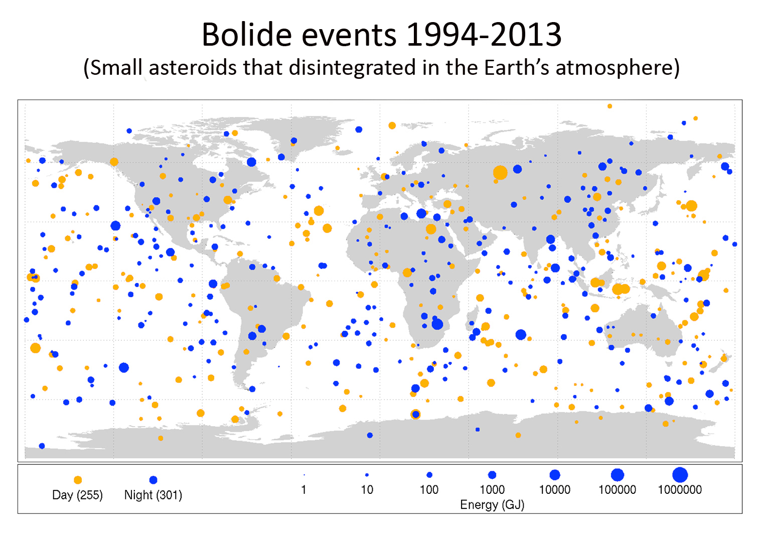
| বিবরণ |
English: New Map Shows Frequency of Small Asteroid Impacts, Provides Clues on Larger Asteroid Population
This diagram maps the data gathered from 1994-2013 on small asteroids impacting Earth's atmosphere IMAGE: DESCRIPTION: Finding and characterizing hazardous asteroids to protect our home planet is a high priority for NASA. It is one of the reasons NASA has increased by a factor of 10 investments in asteroid detection, characterization and mitigation activities over the last five years. In addition, NASA has aggressively developed strategies and plans with its partners in the U.S. and abroad to detect, track and characterize NEOs. These activities also will help identify NEOs that might pose a risk of Earth impact, and further help inform developing options for planetary defense. The public can help participate in the hunt for potentially hazardous Near Earth Objects through the Asteroid Grand Challenge, which aims to create a plan to find all asteroid threats to human populations and know what to do about them. NASA is also pursuing an Asteroid Redirect Mission (ARM) which will identify, redirect and send astronauts to explore an asteroid. Among its many exploration goals, the mission could demonstrate basic planetary defense techniques for asteroid deflection. |
| তারিখ | |
| উৎস | http://www.jpl.nasa.gov/news/news.php?release=2014-397 (image link) |
| লেখক | NASA/Planetary Science |

|
This map image could be re-created using vector graphics as an SVG file. This has several advantages; see Commons:Media for cleanup for more information. If an SVG form of this image is available, please upload it and afterwards replace this template with
{{vector version available|new image name}}.It is recommended to name the SVG file “SmallAsteroidImpacts-Frequency-Bolide-20141114.svg”—then the template Vector version available (or Vva) does not need the new image name parameter. |


লাইসেন্স প্রদান
| এই ফাইলটি পাবলিক ডোমেইনে আছে কারণ এটি শুধুমাত্র নাসা কর্তৃক নির্মিত হয়েছিল। নাসার কপিরাইট নীতি হচ্ছে যে "নাসা কর্তৃক উল্লেখ না থাকলে নাসার উপাদান কপিরাইট দ্বারা সুরক্ষিত নয়"। (Template:PD-USGov, নাসার কপিরাইট নীতির পাতা অথবা জেপিএল চিত্র ব্যবহারের নীতি দেখুন।) | ||
 |
সতর্কবার্তা:
|
ফাইলের ইতিহাস
যেকোনো তারিখ/সময়ে ক্লিক করে দেখুন ফাইলটি তখন কী অবস্থায় ছিল।
| তারিখ/সময় | সংক্ষেপচিত্র | মাত্রা | ব্যবহারকারী | মন্তব্য | |
|---|---|---|---|---|---|
| বর্তমান | ০২:১৭, ৮ ডিসেম্বর ২০১৮ | | ১,৫১৯ × ১,০৬৪ (৬০৮ কিলোবাইট) | wikimediacommons>Hohum | Cleanup title area |
ফাইলের ব্যবহার
নিম্নলিখিত পাতাটি এই ফাইল ব্যবহার করে: